
The Kab-Ash Trail: A Path through the Wild North
By Tom Gable

"The beauty and charm of the wilderness are his for the asking, for the edges of wilderness lie close beside the beaten roads of present travel...through the northern forests, the home of the giant moose, the forests of fragrant and murmuring life in summer, the iron-bound and melancholy of winter. The joy of living is his who has the heart to demand it"
- Theodore Roosevelt, The Joy of the Wild
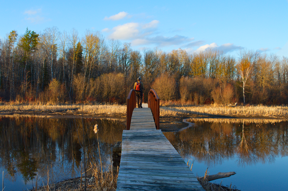
Few that ever come to Voyageurs wander down the more than 20-some-mile long Kab-Ash Trail that runs from the resort community of Ash River and ends near Kabetogama, Minnesota. The Kab-Ash is the only large trail network in Voyageurs National Park that can be accessed year-round without a boat. The trail only has a few access points and typically the conditions during the summer—when most visit the park— are buggy, hot, and humid. Further the verdant Minnesota summers quickly swallow the trail in vegetation as the Kab-Ash is not regularly maintained throughout the summer. Given all of this, few ever use the trail making it an ideal path for those who crave a true wilderness experience. Over the past 3 years, I have hiked, for both research purposes and recreation, more than 200 miles on the Kab-Ash. Though the Kab-Ash trail does not have the scenic overlooks of famous trails in other national parks, it has a subtle magnetism and beauty—a beauty that is only found when spending time in seldom-visited wild places.
There is no doubt that the Kab-Ash is a wilderness trail. You almost certainly will not see another soul when on the trail and the miles of thick forests surrounding the trail stifle the sounds of the modern world. Indeed, once you get away from the trailhead the only sounds you will hear are the wind whispering through the weathered tops of the pines, the red squirrels alarmed by an intruder, and the gentle notes of birds all around. As a result, the Kab-Ash is a refuge of sorts, a place for reflection, contemplation, and introspection, a place to ponder the natural cycle of every living creature, to wrestle with the struggles of one’s life. On several days when I have simply needed to think and consider, I have rambled down the Kab-Ash for a few miles and mulled through the thoughts that were troubling me. Sometimes, I would just sit down at the base of a towering pine or on the roots of some ancient cedar, and be still. Sit, listen and observe. There is something refreshing and intoxicating about being a silent observer in a world where your problems or struggles are irrelevant, where life goes on the same day after day with or without you. Indeed, the eternality of nature provides a certain clarity regarding the brevity of our own lives and the often inconsequential nature of the problems we face.

The open rock ridges of the Kab-Ash are particularly beautiful in the fall.
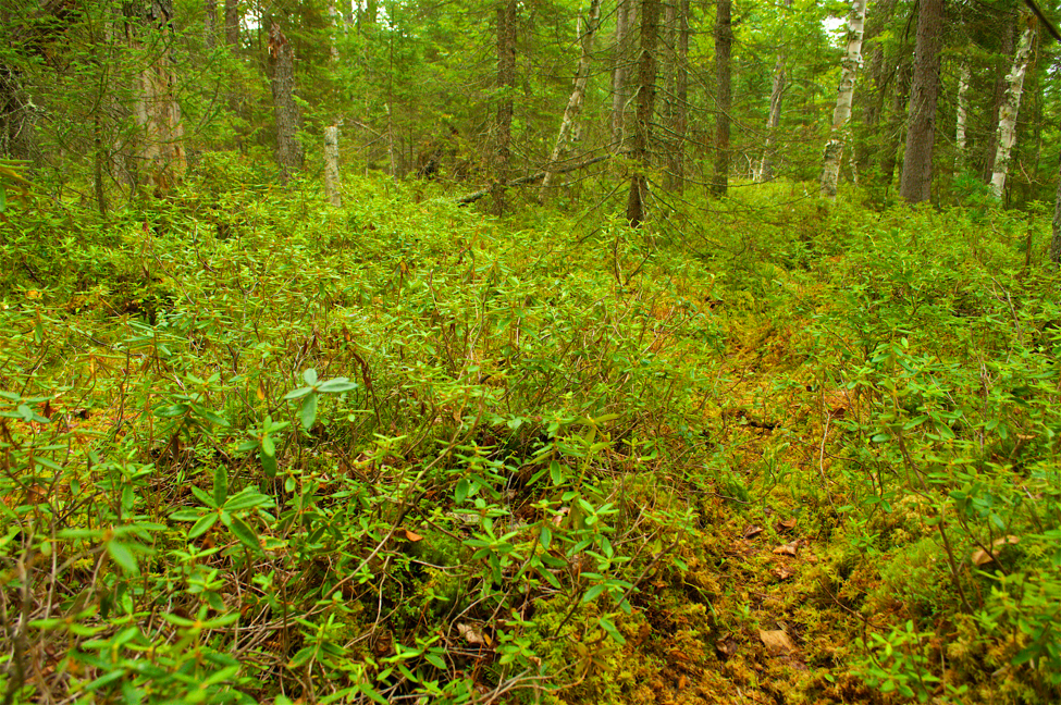
Yet, it is the wild and natural aspects of the Kab-Ash which facilitate its emotional value to wanderers such as myself. From one walk down the Kab-Ash, one could experience almost every habitat type in northern Minnesota and for this reason I would argue that the Kab-Ash, more than any trail in the park, is a perfect representation of the incredible diversity of forest and wetland habitats that Voyageurs National Park protects. Indeed, the Kab-Ash goes through the iconic mixed forests (coniferous and deciduous trees) of the northwoods, over red pine covered ridges (which are not common in VNP), through dark primordial cedar lowlands, across large sparsely vegetated barren rock ridges, around beaver ponds, through black spruce, tamarack and leatherleaf bogs, and along some stunning aspen and birch stands. Due to this large variety of habitats, incredible numbers of birds can be seen or heard during the summer on the Kab-Ash. Warblers, finches, and vireos fill the treetops of the upland forests while the thrushes and veeries seem to hide in the darker, more secretive areas. On a calm June morning just at sunrise, the sound of bird song on the Kab-Ash—or any area in Voyageurs for that matter—can be almost deafening from the multitudes of winged sentinels welcoming in another northern day. I am always left with a sense of splendor and wonderment when witnessing such vitality and vigor from these small creatures. How they make the woods seem to boil with life!
Many of the park’s larger residents also occupy haunts along the Kab-Ash, and though seeing them is rare, often some sign of these animals can be found. When snowshoeing on the Kab-Ash, I almost always see fisher, marten, and fox tracks in the snow. The foxes, it seems, like to use the Kab-Ash to travel as I have followed fox tracks for over a mile on the trail. In June 2016, I saw a female porcupine with a small porcupette (a porcupette is a baby porcupine) on the Kab-Ash, which was the first time I had ever seen a porcupette. Although uncommon, moose tracks can be found on the trail from time to time. In late summer, when the blueberries are ripe, some bears head for the large rock ridges that the Kab-Ash crosses over to eat berries. The blueberries are incredibly abundant in these places (another great reason to hike the Kab-Ash!) and thus these ridges are likely an excellent place for bears to start gaining weight for winter. Beavers commonly dam up the small creeks that the Kab-Ash crosses. There is a quaint woodland creek with a small foot bridge that crosses the Kab-Ash about 2 miles from the trailhead at the Beaver Pond Overlook. For the past 3 years the creek has quietly flowed out of a large black spruce bog, across the Kab-Ash, down a steep hill, into another beaver pond, and then into Lake Kabetogama. In summer 2017, however, a brave beaver or two worked their way up the steep hill, dammed the creek, and created a new pond about 100 yards from the Kab-Ash.

A new beaver pond, created during summer 2017, about 100 yards from the Kab-Ash trail (photograph taken in late October 2017).
Then there are the wolves. Many come to Voyageurs and other parts of northern Minnesota excited about the prospect of seeing a wolf, which often does not happen (I studied wolves all last summer and only saw 1 wolf during this period and it was crossing the highway). Although your odds of seeing a wolf are extremely low on the Kab-Ash, wolf sign generally abounds, especially in the winter. The Kab-Ash goes right through the heart of two wolf packs— one that occupies the area east of Daley Bay and west of the Meadwood Road (the road to the Ash River visitor center), and another that occupies the area west of Daley Bay. In the summer wolves use the trail to get around their territory and while doing so commonly deposit scats (wolf turds) on the trail. And though you might not see a wolf, you could hear one. In 2015, I heard wolves howling off the Kab-Ash trail several times during the summer. In the winter, there are almost always wolf tracks somewhere along the Kab-Ash. In fact, I have yet to hike the Kab-Ash in the winter and not find wolf tracks. Just a few months ago in late October 2017, after a fresh snow, I was following a set of fresh wolf tracks down the Kab-Ash. The tracks veered off the trail, crossed the newly created beaver dam mentioned above and went over the beaver lodge where the beavers had been busy working the night before. I am guessing the wolf was hoping he could find an easy, free meal!
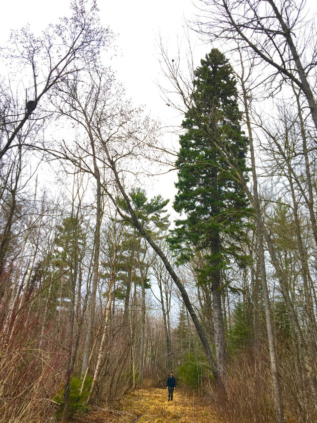
The most incredible area of the entire Kab-Ash, however, has remained seemingly undiscovered or at least unknown to almost everyone. When I first found this area on the section of trail just south of Irwin Bay I was in awe and beside myself for days. There, among the Voyageurs forest, a small grove of monstrous, old growth white pines with one giant, ancient white spruce. In total, I identified 8 white pines in a few hundred feet that were all over 4 feet in diameter, with one pine that had recently died measuring a staggering 5 feet in diameter. It is hard for me to put into words my feelings when standing next to these trees…I think one simply has to experience it. Based on some measurements, I estimated the trees were >300-400 years old. Consider that…these pines are probably older than our country! Moreover, these trees were almost certainly around in the days of the Voyageurs and perhaps could even hear the Voyageurs’ song as it danced across the water! Amazingly, for some reason almost a century ago, these old-growth trees were spared from the saw. I like to think that an old grizzled lumberjack, reflecting on the plight of the northern forests, left this stand for posterity and for others to enjoy decades after his time. After my discovery, I asked some park staff if they were aware of this grove of giants but could not find anyone who knew of this place. Though the grove is about 4 miles from the nearest trailhead, the reward of seeing these trees is worth all the effort. Thoreau shared a similar sentiment regarding majestic trees, exclaiming, “I frequently tramped eight or ten miles through the deepest snow to keep an appointment with a beech-tree, or a yellow birch, or an old acquaintance among the pines”.

A monstrous white pine, estimated to be more than 300-400 years old, just off the Kab-Ash south of Irwin Bay. This pine is part of an old-growth stand that has remained seemingly undiscovered or at least unknown to almost everyone for many years. If there is one spot you should hike to on the Kab-Ash, this is it.
As aforementioned, the Kab-Ash traverses a variety of different habitats with unique and specific characteristics based on the topography, moisture, and soil type, which all influence the plant and animals that live in these areas. When starting at the Beaver Pond Overlook trailhead heading west (I have omitted discussing the ~3 mile stretch from the Beaver Pond Overlook to the community of Ash River), the path works its way around the well-known beaver pond and then climbs and descends several small rocky ridges covered with majestic white pines and blueberry bushes. The trail then reaches the first of several “loops”. You can either take the south or the north section of the loop. I suggest taking the south section first (take the north section on the way back) which climbs up a large granitic ridge covered in scrub oak, some weather-beaten pines, and vast amounts of blueberry bushes. The best views on the Kab-Ash trail are on this ridge and in certain spots you can look south for miles upon miles (this is especially true during winter when the leaves have dropped). The trail then works its way down the backside of the ridge through a jack pine and spruce forest before winding around a black spruce bog and the new beaver pond that I mentioned above. After passing the new beaver pond (and the creek that runs out of it and under the Kab-Ash), the trail continues for almost a mile through predominantly balsam fir and aspen forest before reaching the second loop of the trail. However, in this stretch the trail also crosses some dense red pine covered ridges and follows a boardwalk that meanders through a cool, mossy cedar lowland. There is also a giant white pine about 300 ft north of the trail in this section. It is hard to describe where exactly but you can see the pine towering above the rest of the forest if you look carefully.
At the second loop, I suggest taking the southern section which slowly climbs a large rocky ridge. Eventually the trail reaches the top of the ridge where there are scattered jack pines, blueberry bushes, and open rock faces. If you reach this section you are about 5-6 miles from the trailhead. This area is quite remote and I suspect only a handful of people ever actually hike this far down the trail each year. In 2015, this area was used so little that a wolf pack established a rendezvous site (a place where the pups are kept in the summer while the adults go out to hunt food) on the rock ridge right next to the cairns of the Kab-Ash trail. After reaching the open rocky area the trail quickly descends down the ridge into the forest, curls around a beaver pond that is in a valley (by Minnesota standards) between two large rock ridges, and quickly starts to ascend the next big ridge. Once you get up the rock ridge, you reach the third loop on the trail. Again, I suggest taking the south loop which weaves and winds across the open granitic ridge top for about 0.3-0.5 miles. The trail then slowly descends, for about 0.5 miles, into white pine, birch, aspen, and balsam fir forest and before long the trail flattens out for about 1-1.5 miles as it goes through mixed forest lowlands. In the springtime this section can be quite soggy, however, there are some magnificent white spruce trees on the west side of the trail. In one spot, there are 5-6 lumbering spruces within a few feet of each other which is the largest grove of “big” spruces I have seen in the park. At the end of this section is a long (>100 ft) bridge that crosses the east fork of Daley Bay. The bridge is a great spot to take a break and enjoy the scenery. Waterfowl such as ducks, geese and swans love this part of Daley Bay, and there is a beaver lodge close by the bridge where beavers are often out swimming around.
The bridge that crosses Daley Bay is an excellent place to observe waterfowl and take in the evening sunlight.
After the bridge you continue down the trail through more lowland forest. Keep your eye out for an enormous aspen, about 3.5 ft in diameter, right next to the trail…I have measured a lot of aspen trees in VNP and few even come close to the size of this aspen. About 1 mile from the bridge the Kab-Ash intersects a snowmobile trail. If you continue straight ahead after crossing the snowmobile trail you will quickly reach the trailhead for the Kab-Ash on Ash River Trail Road (i.e., a parking lot). However, if you want to continue hiking more of the Kab-Ash, then turn west and follow the snowmobile trail until it crosses, via a small bridge, the west fork of Daley Bay. Just a warning, the snowmobile trail is swampy as you get closer to the west fork of Daley Bay so use caution. One misplaced step and you might have wet feet for the rest of your hike. Right after you cross the bridge over Daley Bay, keep your eye out for the trail which veers north off the snowmobile trail. The trail is poorly marked in this area but it is no more than 30 ft to the west of the bridge. Once on the trail, you will walk along Daley Creek through largely white spruce, balsam, and aspen forest. I find this section of the trail to be a very peaceful, tranquil stretch. The trail eventually ascends some small aspen and pine covered ridges before reaching a marvelous section of the Kab-Ash: the bog.
An intimate view of a black spruce bog which are common in Minnesota. Bogs are very hard to walk through during the summer but luckily the Kab-Ash has a long boardwalk that goes through a bog which allows hikers a close-up look at one of Minnesota's most unique ecosystems.
Bogs are wet, soggy, hard to access places that have unique plant communities and are immensely beautiful. Fortunately, the Kab-Ash has a half mile of boardwalk that takes travelers right through the heart of a bog. The boardwalk weaves around mounds of sphagnum moss and Labrador tea, across black spruce and white cedar roots, and through stretches of tamarack forest. For a little while, you can experience a world that does not appear to change, a primordial place beyond time’s reach where the forest seems, per Gordon Lightfoot, “too silent to be real”. The boardwalk through the bog does not appear to have been maintained in some time and in some areas the boardwalk floats up and down with the water level in the bog. I have crossed this section multiple times and kept my feet dry in hiking boots. However, exercise caution when crossing this section and go slowly as the boardwalk is often damp or covered in water, and therefore slippery. Nonetheless, this is one of my favorite sections to hike and there is no other place in Voyageurs where you literally walk through a bog and see it from the inside out.

Snowshoeing down the Kab-Ash is an excellent way to see Voyageurs and experience the splendor of winter.
The trail then meanders through some rocky mixed forest woodlands until climbing a peaceful red pine covered ridge—a place that has an ethereal, almost heaven-like, quality when warm beams of sunshine slip through the red pine boughs and illuminate patches of forest below. I think it does the soul well to sit in places like this for a few moments to soak in the wonder; akin to Gordon Lightfoot’s sentiments, “Just for now I’d like to rest in the shade of a maple tree, to the blue Canadian sky I’ll say a prayer for the world out there”. After the ridge, the trail flattens out and follows the base of a fair-sized rock ridge to the north through an aspen and birch forest. This stretch of forest, however, is unique because it has a relatively open understory which allows travelers to see through the forest (this is uncommon in the dense boreal forest of VNP). This stand is especially glorious in the spring and fall when the colors of tree buds or turned leaves glisten against blue skies. Another highlight of this section is a large, lone spruce tree right along the trail. After reaching this spruce, the trail heads north and skirts along the southwestern edge of a massive active beaver pond, which my friend and fellow wolf researcher, Austin Homkes has named “Dead Birch Pond”, due to the large quantity of dead birch trees poking out of the bog mat in the pond. The trail actually crosses just below the dam of the pond and in 2016-2017 the beavers were particularly active in this area, cutting several large balsam poplar and aspen, some of which fell over the trail. In fact, in spring of 2017, the beavers were actually using the Kab-Ash as a trail to reach trees to cut.


There are some beautiful aspen and birch stand along the Kab-Ash.
For another ¾ miles, the trail undulates over small rocky knolls and down into lowland forests before reaching the southern tip of Bowman Bay. When there are no leaves on the trees, Bowman Bay/Lake Kabetogama can be seen easily from the trail. After passing Bowman Bay, the trail turns swampy for about a half-mile as the terrain becomes flat, wet, and soggy. Ash lowlands predominate this stretch, with some enormous, stately cedar trees scattered about, and in the spring marsh marigolds carpet the forest floor in bright yellow. This trek through the swamp, though, is worth every muddy step because just beyond it lies the old growth forest discussed above. You will know when you reach this cathedral because right on the north side of the trail will be a towering white spruce and just beyond on the south side of the trail will be more of the ancient beasts—the pines are so much larger and taller than the rest of the trees that you cannot miss them. Take some time and revel in this natural wonder! Once passing through this old growth grove, all other trees on the Kab-Ash pale in comparison.
This towering old growth spruce that lingers high above the Kab-Ash marks the location of a grove of old-growth trees. Monstrous white pines can be seen in the background behind this spruce.
After passing this grove, the next 2 miles go through relatively flat mixed forest habitats until reaching a recently logged area that is just outside of the park. The trail follows the main logging road used to harvest this stand of cedars. In all seasons this logging road is muddy, wet and messy, and in the summer the vegetation on the road is incredibly dense because the trail is not well-maintained in this section. I generally choose to hike on the edge of the road where it is a little less wet and the vegetation not as thick. Eventually the logging road/Kab-Ash reaches the Arrowhead Snowmobile trail, and on the other side of the trail the Kab-Ash continues as a small hiking path through the primeval-looking cedar forests. The trail crosses a drained beaver pond via a boardwalk, continues through more cedar forest, and crosses the Arrowhead snowmobile trail once again. The last mile or so of the Kab-Ash goes through thick balsam forest and the typical mixed forest habitats of northern Minnesota. The last few miles of the Kab-Ash are not the most enthralling of the trail but still have that exquisite Northwood’s beauty.
The Kab-Ash is an obscure trail in a national park best known for fishing and boating, not hiking and exploring the wilderness. However, I would argue that the Kab-Ash, and most of Voyageurs National Park, is for all lovers of wilderness. Indeed, anyone who appreciates and enjoys the sights, sounds, and solitude of expansive areas of untouched forest, water, and wetlands would feel at home in the Park. Although the sound of boat motors might be prevalent on the main lakes of Voyageurs, it does not take much to escape the sound of the machines and find oneself in the midst of the wild north, a place where man is but an observer and witness to the grandeur of the natural world. It is here that the true beauty of Voyageurs lies. Dick Proenekke, a bushman and wilderness lover from Alaska, stated that one “who walks the land knows the land”. If you want to know Voyageurs National Park, the Northwoods, and wilderness itself, take a walk down the Kab-Ash. ♦